Geography terminology
Every key term, with its definition and a picture where one helps. Tap a bold word in the notes to see it there too.
432 terms
A
Abrasion
Erosion caused when material carried by water or ice scrapes and wears away rock.
Notes: Waves and coastal processes (Coastal landscapes option) · River profiles and processes (River landscapes option) · Ice and glacial processes (Glacial landscapes option) · Glacial landforms of erosion (Glacial landscapes option)
Active layer
The top layer of soil above permafrost, which thaws in summer.
Notes: Cold environments (Cold environments option)
Adaptation
A change that helps people, plants or animals cope with conditions in their environment.
Notes: Managing climate change · Tropical rainforests · Hot desert environments (Hot deserts option) · Cold environments (Cold environments option)
Aerial photograph
A photograph taken from the air to show a landscape from above; it may be oblique or vertical.
Notes: Map skills
Aeroponics
Growing plants with their roots in the air, sprayed with a mist of water and nutrients.
Notes: Increasing food supply (Food option)
Aerospace
The industry that designs and makes aircraft, spacecraft and related equipment.
Notes: A UK city: Bristol
Aftershock
A smaller earthquake that follows a large one, as the rocks settle.
Ageing
A population is ageing when the proportion of older people rises, often as younger people move away.
Notes: Change in the UK's regions
Agribusiness
Farming run as a large business, using intensive, high-tech methods.
Notes: Food, water and energy in the UK · Increasing food supply (Food option)
Aid
Help, such as money, goods or skills, given by one country or organisation to another.
Notes: Closing the development gap · Nigeria: trade, aid and quality of life
Air mass
A large body of air with a similar temperature and moisture, which brings its weather to the places it covers.
Notes: Weather hazards in the UK
Annotation
A note on a diagram, sketch or photo that explains a feature, not just names it.
Notes: Map skills
Anomaly
A result that doesn't fit the overall pattern.
Notes: Fieldwork: presenting data · Fieldwork: analysing data and concluding
Antarctic Treaty
The 1959 agreement that keeps Antarctica for peaceful purposes and science.
Notes: Protecting cold environments (Cold environments option)
Appropriate technology
Technology suited to local people's needs, skills and resources.
Notes: Desertification (Hot deserts option) · Increasing food supply (Food option)
Aquifer
A layer of rock underground that stores water.
Notes: Water security (Water option) · Sustainable water supply (Water option)
Arête
A sharp, narrow ridge between two corries.
Notes: Glacial landforms of erosion (Glacial landscapes option) · A glaciated upland: the Lake District (Glacial landscapes option)
B
Backwash
Water that flows back down a beach towards the sea after a wave breaks.
Notes: Waves and coastal processes (Coastal landscapes option)
Bar
A ridge of sand or shingle across a bay, joining two headlands.
Notes: Coastal landforms of deposition (Coastal landscapes option) · Fieldwork: presenting data · Graphs and maps
Barrage
A low dam across a river, such as the Tees Barrage, which holds back the tide.
Notes: A UK river valley: the River Tees (River landscapes option)
Bay
A curved inlet of the sea between two headlands, often with a beach.
Notes: Developing cold environments (Cold environments option) · Waves and coastal processes (Coastal landscapes option) · Coastal landforms of erosion (Coastal landscapes option) · Coastal landforms of deposition (Coastal landscapes option) · A UK coastline: Swanage (Coastal landscapes option) · A city in an NEE: Rio de Janeiro
Beach
A build-up of sand and shingle on the coast, deposited by waves.
Notes: Landscapes on maps · Coastal landforms of erosion (Coastal landscapes option) · Coastal landforms of deposition (Coastal landscapes option) · A UK coastline: Swanage (Coastal landscapes option)
Beach nourishment
Adding sand or shingle to a beach to make it wider and higher.
Notes: Managing the coast (Coastal landscapes option) · A coastal management scheme: Lyme Regis (Coastal landscapes option)
Best-fit line
A straight line drawn through the middle of the points on a scatter graph, to show the trend.
Notes: Fieldwork: presenting data
Bias
When results are unfairly influenced, so they don't represent the whole area or group.
Notes: Fieldwork: collecting data
Bilateral aid
Aid given directly by one government to another.
Biodiversity
The variety of plant and animal species in an area.
Notes: Tropical rainforests · Managing tropical rainforests · Hot desert environments (Hot deserts option) · Cold environments (Cold environments option)
Biome
A large-scale ecosystem, such as a tropical rainforest or a hot desert, found where the climate suits it.
Notes: Ecosystems
Brownfield site
Land that has been built on before and can be reused.
Build back better
Rebuilding after a disaster so that homes and infrastructure are safer and stronger than before.
Bulldozing
The pushing of loose rock and soil by the front of a moving glacier.
Notes: Ice and glacial processes (Glacial landscapes option)
Buttress roots
Large roots that spread out from the base of a rainforest tree, supporting it in thin soil.
Notes: Tropical rainforests
C
Canopy
The dense layer of treetops in a rainforest, about 30 m up, home to most of its animals.
Notes: Tropical rainforests
Capacity to cope
How well people and governments can prepare for, respond to and recover from a hazard.
Carbon capture
Capturing carbon dioxide from power stations or factories and storing it deep underground.
Notes: Managing climate change · Sustainable energy supply (Energy option)
Carbon dioxide
A gas in the atmosphere that increases the greenhouse effect; burning fossil fuels and cutting forests release it.
Carbon footprint
The amount of greenhouse gas released by a person, product or activity.
Notes: Food, water and energy in the UK · Sustainable energy supply (Energy option)
Carbonation
Chemical weathering in which weak acid in rainwater dissolves limestone and chalk.
Notes: Waves and coastal processes (Coastal landscapes option)
Choropleth map
A map in which areas are shaded according to a value, darker for higher.
Climate graph
A graph showing a place's average monthly rainfall as bars and temperature as a line.
Notes: Graphs and maps
Colonialism
One country ruling another, often taking its resources and wealth.
Notes: Uneven development
Command word
The word in a question that tells you what to do, such as "describe" or "explain".
Notes: Exam skills: Paper 1
Commercial farming
Farming to sell crops or animals for profit, such as oil palm plantations.
Notes: Deforestation
Commonwealth
A voluntary association of 56 countries, most of them once part of the British Empire.
Notes: Nigeria: trade, aid and quality of life · The UK in the wider world
Commuter settlement
A town or village where many people live but travel to work in a city.
Conclusion
An answer to an enquiry's question, supported by evidence from the data.
Notes: Fieldwork: analysing data and concluding · Exam skills: Paper 3
Concordant coast
A coast where bands of rock run parallel to the sea.
Notes: Coastal landforms of erosion (Coastal landscapes option) · A UK coastline: Swanage (Coastal landscapes option)
Conservation
Protecting and managing the natural environment so it survives for the future.
Notes: Managing tropical rainforests · Protecting cold environments (Cold environments option) · Land use and tourism in glaciated uplands (Glacial landscapes option)
Conservative margin
A plate margin where two plates slide past each other, causing earthquakes but no volcanoes.
Notes: Plate tectonics
Constructive margin
A plate margin where two plates move apart and magma rises to form new crust.
Notes: Plate tectonics
Constructive wave
A low wave with a strong swash and weak backwash, which builds up a beach.
Notes: Waves and coastal processes (Coastal landscapes option)
Consumption
The amount of a resource that people use.
Notes: Resources around the world · Food security (Food option) · Energy security (Energy option)
Contour interval
The difference in height between neighbouring contour lines.
Notes: Landscapes on maps
Contour line
A line on a map joining places of the same height above sea level.
Notes: Landscapes on maps · Map skills
Convection current
A circular movement of hot rock in the mantle, which rises, spreads, cools and sinks, dragging plates along.
Notes: Plate tectonics
Coriolis effect
The bending of winds and ocean currents caused by the Earth's spin.
Correlation
A relationship between two variables: positive if both rise together, negative if one falls as the other rises.
Notes: Fieldwork: presenting data
Corrie
An armchair-shaped hollow on a mountainside, with a steep back wall, carved by a glacier.
Notes: Landscapes on maps · Glacial landforms of erosion (Glacial landscapes option) · A glaciated upland: the Lake District (Glacial landscapes option)
Cost-benefit analysis
Comparing the costs of a scheme with the value of what it protects, to decide whether it is worth doing.
Notes: Managing the coast (Coastal landscapes option) · A coastal management scheme: Lyme Regis (Coastal landscapes option)
Cross profile
The shape of a river valley from one side to the other.
Notes: River profiles and processes (River landscapes option)
Cross-section
A side view of the shape of the land along a line, drawn from the contours on a map.
Notes: Landscapes on maps
Crust
The thin, solid outer layer of the Earth, on which the continents and ocean floors rest.
Notes: Plate tectonics
D
Dam
A barrier across a river that holds back water, forming a reservoir.
Notes: Deforestation · Increasing water supply (Water option) · Sustainable water supply (Water option)
De-industrialisation
The decline of manufacturing industry in a country or region.
Notes: The UK's changing economy
Debt-for-nature swap
An agreement to cancel part of a country's debt in return for protecting its forests or other nature.
Decomposer
A living thing, such as a bacterium or fungus, that breaks down dead plants and animals.
Notes: Ecosystems
Deforestation
The cutting down and removal of forest.
Notes: Climate change: evidence and causes · Deforestation · Flood risk and hydrographs (River landscapes option) · Nigeria: trade, aid and quality of life
Demographic Transition Model
A model showing how a country's birth and death rates, and population, change as it develops.
Notes: Measuring development
Deposition
The dropping of material that a river or the sea has been carrying, when it loses energy.
Notes: Waves and coastal processes (Coastal landscapes option) · River profiles and processes (River landscapes option)
Deprivation
A lack of things people need for a good standard of living, such as income, jobs, health and education.
Dereliction
Land and buildings left empty and abandoned.
Desalination
Removing salt from seawater to make fresh water.
Notes: Increasing water supply (Water option)
Desert fringe
The area at the edge of a hot desert, where rain is low and unreliable.
Notes: Desertification (Hot deserts option)
Desertification
The process by which land in dry areas becomes more like a desert, losing its plants and soil.
Notes: Hot desert environments (Hot deserts option) · Desertification (Hot deserts option)
Destructive margin
A plate margin where an oceanic plate sinks beneath a continental plate, causing earthquakes and explosive volcanoes.
Notes: Plate tectonics · Effects of and responses to earthquakes
Destructive wave
A high, steep wave with a weak swash and strong backwash, which erodes a beach.
Notes: Waves and coastal processes (Coastal landscapes option)
Development
The progress a country makes in improving the lives of its people.
Notes: Deforestation · Measuring development · Closing the development gap · The UK's changing economy · Resources around the world · Food security (Food option) · Increasing food supply (Food option) · Water security (Water option) · Energy security (Energy option)
Development gap
The difference in standards of living between the world's richest and poorest countries.
Notes: Uneven development
Devolution
Passing power and money from central government to regions or cities.
Notes: Change in the UK's regions
Directional drilling
Drilling at an angle, to reach oil far from the drilling site, so fewer sites are needed.
Notes: Protecting cold environments (Cold environments option)
Discharge
The volume of water flowing past a point in a river each second, in cubic metres per second (m³/s).
Notes: River profiles and processes (River landscapes option) · Flood risk and hydrographs (River landscapes option)
Discordant coast
A coast where bands of hard and soft rock meet the sea at right angles.
Notes: Coastal landforms of erosion (Coastal landscapes option) · A UK coastline: Swanage (Coastal landscapes option)
Diurnal temperature range
The difference between the highest temperature in the day and the lowest at night.
Notes: Hot desert environments (Hot deserts option)
Dolerite
A hard igneous rock, which forms the Whin Sill at High Force.
Notes: A UK river valley: the River Tees (River landscapes option)
Dredging
Removing silt from a river bed, so the channel can hold more water.
Notes: Weather hazards in the UK
Drumlin
A smooth, oval hill of till, shaped by moving ice, with its tapering end pointing the way the ice moved.
Notes: Glacial landforms of deposition (Glacial landscapes option) · A glaciated upland: the Lake District (Glacial landscapes option)
E
Easting
A grid value that shows how far east a point lies; read it before the northing on an OS map.
Notes: Map skills
Ecotourism
Small-scale, sustainable tourism that protects the environment and benefits local people.
Embankment
A raised bank built along a river so it can hold more water.
Notes: Managing floods (River landscapes option)
Embryo dune
A small, new sand dune that forms around an obstacle on a beach or just inland.
Notes: Coastal landforms of deposition (Coastal landscapes option)
Energy conservation
Reducing the amount of energy used and wasted.
Notes: Sustainable cities · Sustainable energy supply (Energy option)
Energy deficit
When a country uses more energy than it produces.
Notes: Energy security (Energy option)
Energy insecurity
When a country's energy supply is unreliable or too expensive.
Notes: Energy security (Energy option)
Energy mix
The different sources of energy a country uses, such as gas, wind and nuclear.
Energy security
Having a reliable, affordable supply of energy.
Notes: Resources around the world · Energy security (Energy option) · Increasing energy supply (Energy option)
Energy surplus
A country has an energy surplus when it produces more energy than it uses.
Notes: Energy security (Energy option)
Enquiry
An investigation into a geographical question, from planning to evaluation.
Notes: Fieldwork: questions, hypotheses and risk · Exam skills: Paper 3
Environmental quality survey
Scoring the quality of a place on several features, such as litter and noise, to give a total.
Notes: Fieldwork: collecting data
Erratic
A large boulder carried by a glacier and dropped far from where it came from, on a different type of rock.
Notes: Glacial landforms of deposition (Glacial landscapes option)
Estuary
The wide, tidal mouth of a river, where fresh water meets the sea.
Notes: Meanders and flood plains (River landscapes option) · A UK river valley: the River Tees (River landscapes option)
European Union
A group of European countries that trade freely and cooperate closely; the UK left it in 2020.
Notes: The UK in the wider world
Evacuation
Moving people away from a dangerous area before or during a hazard.
Notes: Living with tectonic hazards · Effects of and responses to tropical storms
Evaluate
Weigh up strengths and weaknesses, and come to a judgement.
Notes: Exam skills: Paper 1 · Exam skills: Paper 2
Evaluation
Judging the strengths and weaknesses of an enquiry, and how far its conclusions can be trusted.
Evidence
Facts, figures and examples that support a point, such as data from the booklet.
Notes: Tropical storms · Exam skills: Paper 3 · Map skills · Exam skills: Paper 1
Extrapolation
Estimating a value beyond the range of known data, by extending a trend.
Notes: Statistics
Eye
The calm centre of a tropical storm, where cool air sinks and skies may be clear.
Notes: Tropical storms
Eyewall
The ring of tall clouds around the eye of a tropical storm, with the strongest winds and heaviest rain.
Notes: Tropical storms
F
Fair trade
Trade in which producers in poorer countries are paid a fair price for their goods.
Notes: Closing the development gap
Falling limb
The part of a hydrograph where discharge decreases after the peak.
Notes: Flood risk and hydrographs (River landscapes option)
Famine
A severe, widespread shortage of food, causing starvation and death.
Notes: Food security (Food option)
Fault
A fracture in rock where movement has taken place; faults and joints can form lines of weakness that waves erode.
Notes: Coastal landforms of erosion (Coastal landscapes option)
Favela
The name for an informal settlement in Brazil.
Ferrel cell
The loop of circulating air between 30° and 60°, where air sinks at 30° and rises at 60°.
Fetch
The distance of open water over which wind blows to generate waves.
Notes: Waves and coastal processes (Coastal landscapes option)
Fibre-optic cable
A cable that carries internet and phone data as light, such as under the sea between continents.
Notes: The UK in the wider world
Field sketch
A simple drawing made in the field that shows the main features of a place.
Notes: Map skills
Fieldwork
Collecting data outside the classroom, to investigate a geographical question.
Notes: Fieldwork: questions, hypotheses and risk · Exam skills: Paper 3
Flood plain
The wide, flat land on either side of a river, which floods when the river overflows.
Notes: Landscapes on maps · River profiles and processes (River landscapes option) · Meanders and flood plains (River landscapes option) · A UK river valley: the River Tees (River landscapes option) · Flood risk and hydrographs (River landscapes option)
Flood plain zoning
Planning rules that limit what can be built in the parts of a flood plain most at risk.
Notes: Managing floods (River landscapes option)
Flood relief channel
An artificial channel that carries extra water around a place during a flood.
Notes: Managing floods (River landscapes option)
Flood storage area
An area of land where floodwater is held back on purpose, so it can be let out slowly.
Notes: Managing floods (River landscapes option)
Flow-line map
A map with lines along routes whose width shows how much is moving.
Notes: Graphs and maps
Fold mountains
Mountains formed when layers of rock are compressed and folded as tectonic plates collide.
Notes: Plate tectonics
Food chain
A sequence showing how energy and nutrients pass from one organism to another as each is eaten.
Notes: Ecosystems
Food deficit
A country has a food deficit when it produces less food than it needs.
Notes: Food security (Food option)
Food insecurity
When people don't have reliable access to enough affordable, nutritious food.
Notes: Food security (Food option)
Food miles
The distance food travels from where it is produced to where it is eaten.
Notes: Food, water and energy in the UK · Increasing food supply (Food option)
Food security
When everyone has enough affordable, nutritious food to lead a healthy, active life.
Notes: Resources around the world · Food security (Food option) · Sustainable food supply (Food option)
Food surplus
A country has a food surplus when it produces more food than it needs.
Notes: Food security (Food option)
Food web
A diagram of the links between the food chains in an ecosystem, with arrows from food to feeder.
Notes: Ecosystems
Footpath erosion
The wearing away of paths by walkers' feet, which can strip the ground of plants and soil.
Notes: Land use and tourism in glaciated uplands (Glacial landscapes option)
Fossil fuel
Fuel formed from ancient plant and animal remains, such as coal, oil and gas; burning it releases carbon dioxide.
Notes: Climate change: evidence and causes · Energy security (Energy option) · Increasing energy supply (Energy option) · Sustainable energy supply (Energy option)
Fracking
Pumping water and chemicals into shale rock at high pressure to release gas.
Fragile environment
An environment that is easily damaged and slow to recover.
Notes: Protecting cold environments (Cold environments option)
Freeport
An area with lower taxes and simpler customs rules, to attract businesses and trade.
Notes: Change in the UK's regions
Freeze-thaw weathering
The breaking of rock as water in cracks freezes, expands and thaws again and again.
Notes: Waves and coastal processes (Coastal landscapes option) · Ice and glacial processes (Glacial landscapes option)
Fuel poverty
When a household cannot afford enough energy to keep its home warm and meet its basic energy needs.
Notes: Energy security (Energy option)
G
Gas flaring
Burning off unwanted natural gas at oil wells, which pollutes the air.
Notes: An NEE: Nigeria · Nigeria: trade, aid and quality of life
Genetic modification
Changing an organism's genes, for example to make a crop resist pests or drought.
Notes: Increasing food supply (Food option)
Geological structure
The arrangement of rock layers and features such as joints and faults, which affects how a coastline erodes.
Notes: Coastal landforms of erosion (Coastal landscapes option)
Geology
The rocks of an area, and the study of them.
Notes: The UK's physical landscapes · Water security (Water option) · Energy security (Energy option)
Geothermal energy
Heat from inside the Earth, used to make electricity and heat homes.
Notes: Living with tectonic hazards
Glacial trough
A deep, U-shaped valley with steep sides and a flat floor, carved by a glacier.
Notes: Glacial landforms of erosion (Glacial landscapes option) · A glaciated upland: the Lake District (Glacial landscapes option)
Glacier
A large mass of ice that moves slowly downhill under its own weight.
Notes: The UK's physical landscapes · Ice and glacial processes (Glacial landscapes option)
Globalisation
The growing links between countries through trade, investment, travel and communications.
Notes: Nigeria: trade, aid and quality of life · The UK's changing economy
GNI per head
The total income of a country's people and businesses, including from abroad, divided by its population.
Notes: Measuring development
Gorge
A narrow, steep-sided valley, often formed as a waterfall retreats upstream.
Notes: River landforms of erosion (River landscapes option) · A UK river valley: the River Tees (River landscapes option)
Gradient
How steep a slope is: the rise in height divided by the horizontal distance.
Notes: Map skills
Greenfield site
Land that has never been built on, usually farmland or countryside.
Greenhouse effect
The trapping of heat by gases in the atmosphere, such as carbon dioxide and methane, which keeps the Earth warm.
Greenhouse gas
A gas in the atmosphere that traps heat, such as carbon dioxide or methane.
Notes: Increasing energy supply (Energy option)
Grey water
Used water from sinks, baths and washing machines, which can be reused for things like flushing toilets.
Notes: Sustainable water supply (Water option)
Grid reference
A set of numbers, eastings then northings, that gives a place's position on a map.
Notes: Map skills
Groundwater
Water stored underground, in the soil and in rocks.
Notes: Sustainable water supply (Water option)
Groyne
A wooden or rock fence built down a beach to trap sand moved by longshore drift.
Notes: Managing the coast (Coastal landscapes option)
H
Habitat
The natural place where an organism lives and obtains what it needs.
Notes: Meanders and flood plains (River landscapes option)
Hadley cell
The loop of circulating air between the equator and 30°, where air rises at the equator and sinks at 30°.
Hanging valley
A side valley left high above a glacial trough, often with a waterfall.
Notes: Glacial landforms of erosion (Glacial landscapes option) · A glaciated upland: the Lake District (Glacial landscapes option)
Hard engineering
Using structures such as sea walls, dams or embankments to control natural processes or reduce their impacts.
Notes: Managing the coast (Coastal landscapes option) · Managing floods (River landscapes option)
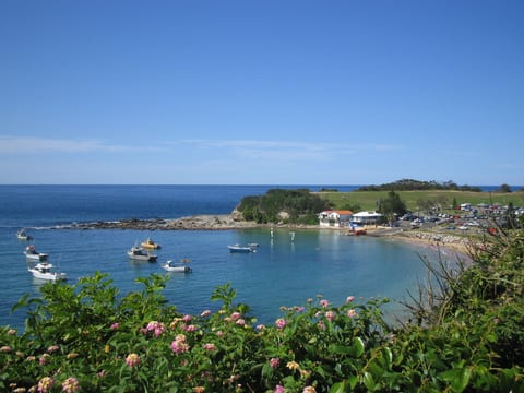
Headland
A piece of hard rock sticking out into the sea, with water on three sides.
Notes: Coastal landforms of erosion (Coastal landscapes option) · A UK coastline: Swanage (Coastal landscapes option)

High pressure
Where air sinks, usually bringing dry, settled weather.
Notes: Global atmospheric circulation · Hot desert environments (Hot deserts option)
Histogram
A bar chart for grouped continuous data, with no gaps between the bars.
Notes: Graphs and maps
Honeypot site
A place that attracts large numbers of tourists, such as Windermere.
Notes: Land use and tourism in glaciated uplands (Glacial landscapes option)
Hot desert
An area that gets less than 250 mm of rain a year and is hot for much or all of it.
Notes: Hot desert environments (Hot deserts option)
Human Development Index
A UN measure of development combining life expectancy, education and income into a score from 0 to 1.
Notes: Measuring development
Hurricane
The name for a tropical storm in the Atlantic Ocean.
Hydraulic action
Erosion by the force of the water, which breaks rock from the bed and banks.
Notes: River profiles and processes (River landscapes option)
Hydraulic power
Erosion by the force of waves, which forces air and water into cracks in the rock.
Notes: Waves and coastal processes (Coastal landscapes option)
Hydroponics
Growing plants without soil, with their roots in water containing nutrients.
Notes: Increasing food supply (Food option)
Hypothesis
A statement that an enquiry tests, to find out whether it is true.
Notes: Fieldwork: questions, hypotheses and risk · Exam skills: Paper 3
I
Ice core
A long cylinder of ice drilled from an ice sheet, whose trapped air shows past temperatures and carbon dioxide levels.
Notes: Climate change: evidence and causes · Protecting cold environments (Cold environments option)
Ice sheet
A very large mass of ice covering a broad area of land, such as Antarctica or Greenland.
Notes: Ice and glacial processes (Glacial landscapes option)
Igneous rock
Rock formed when magma or lava cools, such as granite.
Notes: The UK's physical landscapes
Immediate response
Action in the hours and days after a hazard, such as search and rescue, medical care and shelter.
Impermeable
Not letting water pass through, like clay, granite or concrete.
Notes: Flood risk and hydrographs (River landscapes option)
Inaccessibility
Being hard to reach, because of distance, poor roads or difficult land.
Notes: Developing hot deserts (Hot deserts option) · Developing cold environments (Cold environments option)
Inequality
Large differences between people or places, for example in wealth, health or education.
Infant mortality
The number of babies who die before their first birthday, per 1,000 live births.
Notes: Measuring development
Informal economy
Work that isn't officially registered or taxed, such as street selling, with no job security.
Notes: A city in an NEE: Rio de Janeiro · Challenges and planning in Rio de Janeiro
Infrastructure
The basic structures and services a place needs, such as transport, power, water and communications.
Notes: Developing cold environments (Cold environments option) · Change in the UK's regions · Water security (Water option) · Increasing water supply (Water option)
Inner core
The solid, central layer of the Earth, made mainly of iron and nickel.
Notes: Plate tectonics
Integrated transport
Linking different types of public transport, such as buses and trains, so journeys are easy.
Notes: A UK city: Bristol
Interdependence
The way the parts of an ecosystem, living and non-living, depend on each other.
Notes: Hot desert environments (Hot deserts option) · Cold environments (Cold environments option)
Interdependent
Parts of an ecosystem are interdependent when they rely on one another.
Notes: Cold environments (Cold environments option) · Hot desert environments (Hot deserts option) · Ecosystems · Tropical rainforests
Interglacial period
A warmer period between glacial periods, when ice sheets and glaciers shrink.
Notes: Ice and glacial processes (Glacial landscapes option) · Climate change: evidence and causes
Interlocking spurs
Ridges of high land that jut out from alternate sides of a V-shaped valley and fit together like a zip.
Notes: River landforms of erosion (River landscapes option) · A UK river valley: the River Tees (River landscapes option)
Intermediate technology
Simple, cheap technology suited to the skills and needs of local people.
Notes: Closing the development gap
Interquartile range
The difference between the upper and lower quartiles: the spread of the middle half of the data.
Notes: Fieldwork: analysing data and concluding · Statistics
Irrigation
Supplying crops with water by artificial means, such as canals, channels, sprinklers or pipes.
Notes: Developing hot deserts (Hot deserts option) · Increasing food supply (Food option) · Water security (Water option)
Issue evaluation
Studying a geographical issue, weighing up options and people's views, and making a justified decision.
Notes: Issue evaluation · Exam skills: Paper 3
J
Judgement
A clear decision on how far you agree, or which is best, supported by evidence.
Notes: Exam skills: Paper 1 · Exam skills: Paper 2
Justify
Give reasons and evidence for a decision or opinion.
Notes: Issue evaluation · Exam skills: Paper 3
L
Lag time
The time between peak rainfall and peak discharge.
Notes: Flood risk and hydrographs (River landscapes option)
Lagoon
A body of water cut off from the sea, for example behind a bar.
Notes: Coastal landforms of deposition (Coastal landscapes option)
Landlocked
A country with no coastline is landlocked, which can make overseas trade harder and more expensive.
Notes: Uneven development
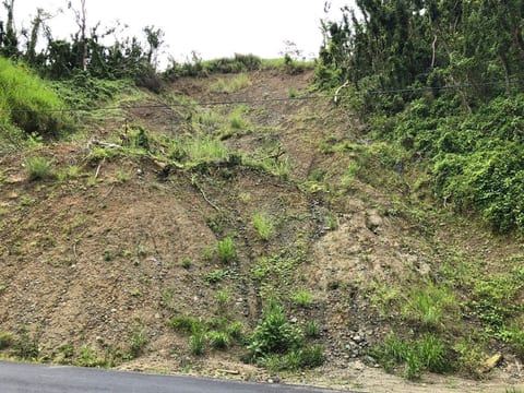
Landslide
A large mass of rock and soil sliding down a slope.
Notes: Effects of and responses to earthquakes · A coastal management scheme: Lyme Regis (Coastal landscapes option) · Challenges and planning in Rio de Janeiro
Lateral erosion
Erosion sideways into the river banks, which widens the valley.
Notes: River profiles and processes (River landscapes option)
Lateral moraine
A ridge of material along the side of a glacier or its valley.
Notes: Glacial landforms of deposition (Glacial landscapes option)
Leakage
Money from tourism that leaves the country, for example as profits for foreign companies.
Notes: Closing the development gap
Levée
A raised bank along a river, built up by deposition during floods.
Notes: Meanders and flood plains (River landscapes option) · A UK river valley: the River Tees (River landscapes option)
Levels marking
Marking a long answer by deciding which level of quality it reaches as a whole.
Notes: Exam skills: Paper 1
Life expectancy
The average number of years a person born now can expect to live.
Notes: Measuring development
Long profile
How a river's height changes from its source to its mouth.
Notes: River profiles and processes (River landscapes option)
Long-term response
Action over months and years after a hazard, such as rebuilding homes and reducing future risk.
Longshore drift
The zigzag movement of sand and shingle along a coast, as waves reach the beach at an angle.
Notes: Waves and coastal processes (Coastal landscapes option) · Coastal landforms of deposition (Coastal landscapes option)
Low pressure
Where air rises, usually bringing clouds and rain.
Lowland
Low, flatter land, as in much of the south and east of the UK.
Notes: The UK's physical landscapes
M
Magnitude
How big or powerful a hazard is, such as the size of an earthquake.
Managed retreat
Letting the sea flood an area of low-value land, in a controlled way, instead of defending it.
Notes: Managing the coast (Coastal landscapes option)
Mantle
The thick layer of hot rock between the Earth's crust and its core; it moves very slowly.
Notes: Plate tectonics
Marram grass
A grass with long roots that binds sand dunes together and grows up through new sand.
Notes: Coastal landforms of deposition (Coastal landscapes option)
Mass movement
The downhill movement of rock and soil under gravity, such as sliding, slumping and rock falls.
Notes: Waves and coastal processes (Coastal landscapes option)
Mean
The total of the values divided by how many there are.
Notes: Fieldwork: collecting data · Fieldwork: analysing data and concluding · Statistics
Meander
A large bend in a river.
Notes: Landscapes on maps · Meanders and flood plains (River landscapes option) · A UK river valley: the River Tees (River landscapes option)
Medial moraine
A ridge of material down the middle of a glacier, where two glaciers have joined.
Notes: Glacial landforms of deposition (Glacial landscapes option)
Median
The middle value when data is put in order.
Notes: Fieldwork: analysing data and concluding · Statistics
Meltwater
Water produced when ice or snow melts, including water flowing beneath or away from a glacier.
Notes: Ice and glacial processes (Glacial landscapes option)
Metamorphic rock
Rock changed by great heat and pressure, such as slate.
Notes: The UK's physical landscapes
Methane
A greenhouse gas released by sources including cattle, rice paddies and fossil-fuel production.
Micro-hydro
A small hydroelectric scheme that uses the flow of a stream to make electricity for a local community.
Notes: Sustainable energy supply (Energy option)
Microfinance
Very small loans to people who can't borrow from banks, to start or grow a business.
Notes: Closing the development gap
Migration
The movement of people from one place to another to live.
Notes: Protecting cold environments (Cold environments option) · A UK city: Bristol · Uneven development
Mineral extraction
Removing valuable rocks and minerals from the ground by mining or quarrying.
Notes: Deforestation · Developing hot deserts (Hot deserts option) · Developing cold environments (Cold environments option)
Misfit stream
A stream too small to have formed the wide valley it now flows through, shaped by a former glacier.
Notes: Glacial landforms of erosion (Glacial landscapes option)
Mitigation
Reducing the causes of climate change, by cutting greenhouse gas emissions or removing them from the atmosphere.
Notes: Managing climate change
Monitoring
Watching for warning signs of a hazard, using scientific equipment.
Notes: Living with tectonic hazards · Effects of and responses to tropical storms
Monsoon
A seasonal wind system that brings a distinct rainy season to parts of South Asia.
Notes: Developing hot deserts (Hot deserts option) · Sustainable water supply (Water option)
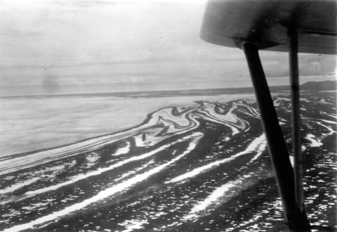
Moraine
A ridge or spread of material deposited by a glacier.
Notes: Glacial landforms of deposition (Glacial landscapes option) · A glaciated upland: the Lake District (Glacial landscapes option)
Mouth
The place where a river meets the sea.
Notes: River profiles and processes (River landscapes option) · A UK river valley: the River Tees (River landscapes option)
Mudflat
A flat area of fine mud exposed at low tide in an estuary or sheltered coast.
Notes: Meanders and flood plains (River landscapes option)
Multilateral aid
Aid given through international organisations, such as the World Bank.
N
National park
An area protected by law for its landscape, wildlife and heritage, and for people to enjoy.
Notes: Managing tropical rainforests · Developing cold environments (Cold environments option) · Protecting cold environments (Cold environments option) · A glaciated upland: the Lake District (Glacial landscapes option)
Natural hazard
A natural event, such as an earthquake or a tropical storm, that threatens people's lives or property.
Natural increase
The birth rate minus the death rate: how fast a population grows without migration.
Notes: Global urbanisation · A city in an NEE: Rio de Janeiro
NEE
A newly emerging economy, such as Brazil or India, whose economy is growing fast.
Notes: Global urbanisation · A city in an NEE: Rio de Janeiro · Measuring development · An NEE: Nigeria · Energy security (Energy option)
Nocturnal
Active at night and resting by day, which helps desert animals avoid the heat.
Notes: Hot desert environments (Hot deserts option)
Non-renewable energy
Energy from a source that will run out, such as coal, oil, gas or uranium.
Notes: Increasing energy supply (Energy option)
North–south divide
The economic and social differences between the south-east of England and the rest of the UK.
Notes: Change in the UK's regions
Northing
A grid value that shows how far north a point lies; read it after the easting on an OS map.
Notes: Map skills
Nutrient cycling
The movement of nutrients from soil or water into plants and animals, and back again when they die and decompose.
Notes: Ecosystems · Tropical rainforests
O
Oblique aerial photograph
An aerial photograph taken at an angle, showing the sides of hills and buildings.
Notes: Map skills
Ocean trench
A deep, narrow depression on the sea floor, formed where one tectonic plate is forced beneath another.
Notes: Plate tectonics
Oil palm
A tropical tree grown for its oil-rich fruit; plantations of it can contribute to deforestation.
Notes: Deforestation
Oil sands
Sand and clay mixed with a thick, heavy oil called bitumen.
Notes: Increasing energy supply (Energy option)
Option
One of the possible choices for dealing with an issue.
Notes: Issue evaluation · Exam skills: Paper 3
Orbital changes
Slow changes in the Earth's orbit, tilt and wobble, which alter how much sunlight it receives and cause ice ages.
Organic farming
Farming without artificial fertilisers or pesticides.
Notes: Sustainable food supply (Food option)
Organic produce
Food grown without artificial fertilisers or pesticides.
Outer core
The liquid layer of iron and nickel surrounding the Earth's solid inner core.
Notes: Plate tectonics
Outwash
Sorted, rounded sand and gravel deposited by meltwater streams from a glacier.
Notes: Ice and glacial processes (Glacial landscapes option)
Over-abstraction
Taking more water from rivers or the ground than is naturally replaced.
Notes: Water security (Water option)
Over-cultivation
Growing crops on land so intensively that the soil loses its nutrients.
Notes: Desertification (Hot deserts option)
Overgrazing
Keeping too many animals on land, so they eat plants faster than they can regrow.
Notes: Hot desert environments (Hot deserts option) · Desertification (Hot deserts option)
Ox-bow lake
A horseshoe-shaped lake formed when a meander is cut off from the river.
Notes: Meanders and flood plains (River landscapes option)
P
Pacifying Police Units
Police units placed in Rio's favelas from 2008 to take back control from drug gangs.
Paris Agreement
The 2015 international agreement to keep global warming well below 2 °C, aiming for 1.5 °C.
Notes: Managing climate change
Peak discharge
The highest discharge a river reaches after a storm.
Notes: Flood risk and hydrographs (River landscapes option)
Percentage change
How much a value has gone up or down, as a percentage of its starting value.
Notes: Statistics
Permaculture
A way of farming that copies natural ecosystems, to keep soil and wildlife healthy.
Notes: Sustainable food supply (Food option)
Permafrost
Ground that stays frozen for at least two years in a row.
Notes: Cold environments (Cold environments option) · Protecting cold environments (Cold environments option)
Planning
Organising where people live and what they do in an emergency, to reduce the effects of a hazard.
Notes: Living with tectonic hazards · Effects of and responses to tropical storms
Plate margin
The place where two tectonic plates meet, where most earthquakes and volcanoes happen.
Notes: Plate tectonics
Plucking
Erosion as meltwater freezes onto rock and the moving glacier pulls pieces away.
Notes: Ice and glacial processes (Glacial landscapes option) · Glacial landforms of erosion (Glacial landscapes option)
Plunge pool
A deep pool at the foot of a waterfall, eroded by the falling water and the rocks it carries.
Notes: River landforms of erosion (River landscapes option)
Point-marked
Marked by giving a mark for each correct point, rather than by levels.
Notes: Exam skills: Paper 1
Polar
A cold environment around the North or South Pole, mostly covered in ice.
Notes: Cold environments (Cold environments option)
Polar cell
The loop of circulating air between 60° and the pole, where air rises at 60° and sinks at the pole.
Population pyramid
A graph showing a population's age and sex structure, with males on one side and females on the other.
Notes: Graphs and maps
Post-industrial economy
An economy in which most people work in services and information, not manufacturing.
Notes: The UK's changing economy
Pre-release booklet
The resources booklet AQA sends to schools 12 weeks before Paper 3, about the issue in Section A.
Notes: Issue evaluation
Prediction
Forecasting when and where a hazard will happen.
Notes: Living with tectonic hazards · Effects of and responses to tropical storms
Pressure system
An area of high or low atmospheric pressure that influences the weather over a region.
Notes: Weather hazards in the UK
Prevailing wind
The wind that most often blows from a particular direction in an area.
Notes: Waves and coastal processes (Coastal landscapes option)
Primary effect
A harm caused directly by a hazard, such as buildings collapsing in an earthquake.
Notes: Effects of and responses to earthquakes · Effects of and responses to tropical storms
Primary forest
Old forest that has never been cleared or logged, rich in species.
Notes: Deforestation
Primary sector
Jobs that take raw materials from the land or sea, such as farming, fishing and mining.
Notes: An NEE: Nigeria
Producer
A living thing that makes its own food from sunlight, such as a plant or algae.
Notes: Ecosystems · Deforestation
Protection
Designing buildings and defences to withstand a hazard.
Notes: Living with tectonic hazards · Effects of and responses to tropical storms · A coastal management scheme: Lyme Regis (Coastal landscapes option)
Pull factor
Something that attracts people to a place, such as better-paid work.
Notes: Global urbanisation · A city in an NEE: Rio de Janeiro
Push factor
Something that makes people want to leave a place, such as a lack of jobs.
Notes: Global urbanisation · A city in an NEE: Rio de Janeiro
Pyramidal peak
A sharp, pointed mountain peak, left where three or more corries have been eroded back to back.
Notes: Glacial landforms of erosion (Glacial landscapes option)
Q
Quality of life
How good people's lives are, including their wealth, health, education and freedom.
Notes: Nigeria: trade, aid and quality of life · Exam skills: Paper 2
Quaternary period
The last 2.6 million years of the Earth's history, in which the climate has swung between glacial and interglacial periods.
Quaternary sector
Jobs in research, information and high-tech services.
Notes: The UK's changing economy
R
Rain band
A band of cloud and rain spiralling round a tropical storm, outside the eyewall.
Notes: Tropical storms
Rainwater harvesting
Collecting and storing rainwater, for example from roofs, for later use.
Notes: Sustainable water supply (Water option)
Range
The difference between the highest and lowest values.
Notes: Hot desert environments (Hot deserts option) · Developing cold environments (Cold environments option) · Fieldwork: analysing data and concluding · Statistics
Refugee
Someone forced to leave their country by war, persecution or disaster.
Notes: Uneven development
Regeneration
Improving a run-down area, through new buildings, jobs and services.
Notes: Managing the coast (Coastal landscapes option) · Challenges and regeneration in Bristol
Reliability
Whether repeating an enquiry would give the same results.
Renewable energy
Energy from a source that won't run out, such as the sun or the wind.
Notes: Developing hot deserts (Hot deserts option) · Sustainable cities · Increasing energy supply (Energy option)
Reservoir
An artificial lake that stores water.
Notes: A UK river valley: the River Tees (River landscapes option) · Managing floods (River landscapes option) · Increasing water supply (Water option)
Resource
Something people need and use, such as food, water or energy.
Notes: Managing tropical rainforests · Uneven development · Resources around the world · Issue evaluation
Ribbon lake
A long, narrow lake on the floor of a glacial trough.
Notes: Glacial landforms of erosion (Glacial landscapes option) · A glaciated upland: the Lake District (Glacial landscapes option)
Rising limb
The part of a hydrograph where discharge increases after rain.
Notes: Flood risk and hydrographs (River landscapes option)
Risk assessment
A plan that lists the hazards of fieldwork and how to reduce them.
River cliff
A steep bank on the outside of a meander, eroded by fast-flowing water.
Notes: Meanders and flood plains (River landscapes option)
Rock armour
Large boulders piled at the foot of a cliff or sea wall to absorb the energy of waves.
Notes: Managing the coast (Coastal landscapes option) · A coastal management scheme: Lyme Regis (Coastal landscapes option)
Rotational slip
The curved, rotating movement of ice in a hollow, which deepens it into a corrie.
Notes: Ice and glacial processes (Glacial landscapes option) · Glacial landforms of erosion (Glacial landscapes option)
Royalty
A payment made for using something, such as Lesotho's water.
Notes: Increasing water supply (Water option) · Increasing energy supply (Energy option)
Run-off
Rainwater that flows over the surface of the ground into rivers.
Notes: Weather hazards in the UK
Rural depopulation
The fall in the number of people living in a rural area, often as young people move away.
Notes: Change in the UK's regions
Rural-urban migration
The movement of people from the countryside to towns and cities.
Notes: Global urbanisation · A city in an NEE: Rio de Janeiro
S
Salinisation
The build-up of salt in soil as irrigation water evaporates, which harms crops.
Notes: Developing hot deserts (Hot deserts option)
Salt marsh
An area of mud and salt-tolerant plants in sheltered water, such as behind a spit.
Notes: Coastal landforms of deposition (Coastal landscapes option) · Managing the coast (Coastal landscapes option) · Meanders and flood plains (River landscapes option)
Saltation
The bouncing of pebbles and sand along a river bed.
Notes: River profiles and processes (River landscapes option)
Sampling
Choosing which sites or people to collect data from, when you can't collect it everywhere.
Notes: Fieldwork: collecting data
Sand dam
A low wall across a seasonal river that traps sand, which stores rainwater for the dry season.
Notes: Sustainable food supply (Food option)
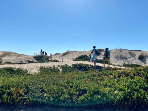
Sand dune
A hill of sand built up by the wind behind a beach.
Notes: Coastal landforms of deposition (Coastal landscapes option) · A UK coastline: Swanage (Coastal landscapes option)

Scale
The relationship between a distance on a map and the real distance on the ground.
Notes: Sustainable energy supply (Energy option) · Fieldwork: presenting data · Map skills
Scatter graph
A graph that plots two variables against each other, to show whether they are related.
Science park
A group of research and high-tech businesses, usually near a university.
Notes: The UK's changing economy
Scree
Loose, angular rock fragments that have fallen from a slope, often through freeze-thaw weathering.
Notes: Ice and glacial processes (Glacial landscapes option)
Sea wall
A concrete wall along the coast that reflects waves back out to sea.
Notes: Living with tectonic hazards · Managing the coast (Coastal landscapes option) · A coastal management scheme: Lyme Regis (Coastal landscapes option)
Second home
A house owned by someone who lives elsewhere and uses it for holidays.
Notes: Land use and tourism in glaciated uplands (Glacial landscapes option)
Secondary data
Data collected by someone else, such as census figures.
Notes: Fieldwork: collecting data
Secondary effect
A harm that happens as a result of the primary effects, such as a tsunami, a fire or homelessness.
Notes: Effects of and responses to earthquakes · Effects of and responses to tropical storms
Sedimentary rock
Rock formed from layers of sediment pressed together, such as chalk, clay and sandstone.
Notes: The UK's physical landscapes
Selective logging
Cutting down only some mature trees, carefully, so the forest can regrow.
Semi-arid
Describes a climate with low rainfall, but more than a true desert usually receives.
Notes: Sustainable food supply (Food option)
Slab pull
The pull of a dense oceanic plate's weight as it sinks into the mantle, which drags the rest of the plate along.
Notes: Plate tectonics
Slip-off slope
A gentle slope of deposited material on the inside of a meander.
Notes: Meanders and flood plains (River landscapes option)
Snout
The end, or lowest edge, of a glacier.
Notes: Glacial landforms of deposition (Glacial landscapes option) · Ice and glacial processes (Glacial landscapes option)
Social opportunity
A chance for people to improve their lives, for example through better health care or education.
Soft engineering
Managing natural processes to reduce impacts, such as beach nourishment or planting trees.
Notes: Managing the coast (Coastal landscapes option) · Managing floods (River landscapes option)
Soil erosion
The removal of soil by wind or water, often made faster when vegetation is removed.
Notes: Deforestation · Desertification (Hot deserts option) · Food security (Food option)
Soil nailing
Driving long steel rods into a slope to pin loose ground to firmer rock beneath.
Notes: A coastal management scheme: Lyme Regis (Coastal landscapes option)
Source
The place where a river begins.
Notes: River profiles and processes (River landscapes option) · A UK river valley: the River Tees (River landscapes option) · Fieldwork: questions, hypotheses and risk
SPaG
Spelling, punctuation, grammar and the use of specialist terms, marked on some long answers.
Notes: Exam skills: Paper 3 · Exam skills: Paper 1
Spit
A long, narrow ridge of sand and shingle, joined to the land at one end, built out into the sea by longshore drift.
Notes: Landscapes on maps · Coastal landforms of deposition (Coastal landscapes option) · A UK coastline: Swanage (Coastal landscapes option)
Spot height
A dot on a map with the exact height of that point, in metres.
Notes: Landscapes on maps · Map skills
Squatter settlement
An area of homes built by people on land they don't own, often without services at first.
Stack
A pillar of rock left standing in the sea when the roof of an arch collapses.
Notes: Coastal landforms of erosion (Coastal landscapes option) · A UK coastline: Swanage (Coastal landscapes option)
Storm hydrograph
A graph of how a river's discharge changes after a period of rain.
Notes: Flood risk and hydrographs (River landscapes option)
Storm shelter
A strong building where people can stay safe during a storm.
Storm surge
A rise in sea level caused by a storm's winds pushing water ashore, which floods coastal areas.
Striation
A long scratch or groove cut into bedrock as rocks carried by a glacier scrape across it.
Notes: Ice and glacial processes (Glacial landscapes option)
Stump
The low remains of a stack after it collapses, covered at high tide.
Notes: Coastal landforms of erosion (Coastal landscapes option) · A UK coastline: Swanage (Coastal landscapes option)
Subduction
The sinking of a dense oceanic plate beneath another plate at a destructive margin.
Notes: Plate tectonics
Subsidence
The sinking of the ground, for example when permafrost under a building thaws.
Notes: Developing cold environments (Cold environments option)
Subsistence farming
Farming to grow food for a family to eat, with little or none left to sell.
Notes: Deforestation
Suspension
The carrying of fine particles, such as silt, in the water.
Notes: River profiles and processes (River landscapes option)
Sustainability
Meeting people's needs today without harming the chances of future generations.
Notes: Issue evaluation
Sustainable
Meeting people's needs today without harming the chances of future generations.
Notes: Managing tropical rainforests · Land use and tourism in glaciated uplands (Glacial landscapes option) · The UK's changing economy · Sustainable food supply (Food option) · Sustainable water supply (Water option) · Sustainable energy supply (Energy option) · Exam skills: Paper 3 · Exam skills: Paper 2
Sustainable management
Using a resource to meet people's needs today without damaging it for future generations.
Sustainable tourism
Tourism that brings benefits now without damaging the environment or local communities for the future.
Notes: Land use and tourism in glaciated uplands (Glacial landscapes option)
Sustainable urban living
Living in a city in ways that meet people's needs today without harming the environment for the future.
Notes: Sustainable cities
Swash
Water moving up a beach after a wave breaks.
Notes: Waves and coastal processes (Coastal landscapes option)
T
Tailings
The waste left after a valuable material, such as oil, has been extracted.
Notes: Increasing energy supply (Energy option)
Tarn
A small lake in a corrie, held in by its rock lip.
Notes: Glacial landforms of erosion (Glacial landscapes option) · A glaciated upland: the Lake District (Glacial landscapes option)
Tectonic hazard
A hazard caused by the movement of the Earth's plates, such as an earthquake or a volcanic eruption.
Tectonic plate
One of the large pieces the Earth's crust is broken into, which move slowly on the mantle.
Notes: Plate tectonics
Terminal moraine
A ridge of material across a valley, marking the furthest point a glacier reached.
Notes: Glacial landforms of deposition (Glacial landscapes option)
Tertiary sector
Jobs that provide services, such as retail, banking and health care.
Notes: An NEE: Nigeria
Till
Unsorted, angular material deposited directly by a glacier.
Notes: Ice and glacial processes (Glacial landscapes option) · Glacial landforms of deposition (Glacial landscapes option) · A glaciated upland: the Lake District (Glacial landscapes option)
To what extent
A command phrase asking you to judge how far you agree, with evidence for both sides.
Notes: Exam skills: Paper 1 · Exam skills: Paper 2
Tourism
Travelling to visit places for leisure; an industry that can bring jobs and money to a country.
Notes: Living with tectonic hazards · Developing hot deserts (Hot deserts option) · Developing cold environments (Cold environments option) · Managing the coast (Coastal landscapes option) · A coastal management scheme: Lyme Regis (Coastal landscapes option) · Land use and tourism in glaciated uplands (Glacial landscapes option) · A city in an NEE: Rio de Janeiro · Closing the development gap
Trade
The buying and selling of goods and services between countries.
Notes: Nigeria: trade, aid and quality of life · The UK in the wider world
Trade deal
An agreement between countries that makes trade between them easier, for example by cutting taxes on imports.
Notes: The UK in the wider world
Trade winds
Surface winds blowing from 30° towards the equator, in the Hadley cell.
Trans-Alaska Pipeline
The pipeline that carries oil about 800 miles from Prudhoe Bay to Valdez, raised over permafrost.
Notes: Developing cold environments (Cold environments option)
Transnational corporation
A company that operates in more than one country, such as Shell.
Notes: An NEE: Nigeria
Tropical storm
A huge, spinning storm with very strong winds and heavy rain, which forms over warm tropical oceans.
Notes: Tropical storms
Truncated spur
A steep cliff on the side of a glacial trough, where a glacier cut through an interlocking spur.
Notes: Glacial landforms of erosion (Glacial landscapes option) · A glaciated upland: the Lake District (Glacial landscapes option)
Tsunami
A series of huge waves caused by the sudden movement of the sea bed, often by an earthquake under the sea.
Tundra
A cold, treeless environment around the Arctic, with long winters and short, cool summers.
Notes: Cold environments (Cold environments option)
Typhoon
The name for a tropical storm in the north-west Pacific Ocean.
Notes: Tropical storms · Effects of and responses to tropical storms
U
Undercutting
Erosion of the rock at the base of a slope or waterfall, leaving an overhang above.
Notes: River landforms of erosion (River landscapes option)
Undernutrition
Not getting enough food, or the right nutrients, to stay healthy.
Notes: Food security (Food option)
Uneven development
The differences in levels of development between countries or regions.
Notes: Uneven development
Unfamiliar fieldwork
An enquiry in the exam paper that you haven't done, which you answer questions about.
Notes: Fieldwork: questions, hypotheses and risk · Exam skills: Paper 3
Upgrading
Improving an existing informal settlement with services, such as water and sewers, rather than knocking it down.
Upland
High, often steep land, such as the mountains of Scotland, the Lake District and Wales.
Notes: The UK's physical landscapes
Urban farming
Growing food or keeping animals in towns and cities.
Notes: Sustainable food supply (Food option)
Urban greening
Increasing the parks, trees and other green spaces in a city.
Notes: A UK city: Bristol
Urban sprawl
The spread of a city outwards into the countryside.
Urbanisation
The growth of towns and cities and the share of a country's people living in urban areas.
Notes: Natural hazards and hazard risk · Flood risk and hydrographs (River landscapes option) · Global urbanisation · Food security (Food option)
V
Vertical erosion
Erosion downwards into the river bed, which deepens the valley.
Notes: River profiles and processes (River landscapes option)
Vulnerability
How likely people are to be harmed by a hazard, for example because of poverty or poor housing.
W
Water conservation
Reducing the amount of water used and wasted.
Notes: Sustainable cities · Sustainable water supply (Water option)
Water deficit
When the demand for water is greater than the supply.
Notes: Food, water and energy in the UK · Water security (Water option)
Water insecurity
When there isn't enough clean water for people's needs.
Notes: Water security (Water option)
Water security
Having enough clean water for people's needs, and for farming and industry.
Notes: Resources around the world · Water security (Water option)
Water stress
When there isn't enough water of good enough quality to meet people's needs.
Notes: Resources around the world · Food security (Food option) · Water security (Water option)
Water surplus
An area has a water surplus when its available water is greater than demand.
Notes: Food, water and energy in the UK · Water security (Water option)
Water transfer
Moving water from an area with a surplus to one with a deficit, using pipes, tunnels or canals.
Notes: Food, water and energy in the UK · Increasing water supply (Water option)
Waterborne disease
A disease spread by drinking or using dirty water, such as cholera.
Notes: Water security (Water option)
Waterfall
A steep drop in a river's course, where it flows over hard rock lying on softer rock.
Notes: River landforms of erosion (River landscapes option) · Glacial landforms of erosion (Glacial landscapes option)
Wave-cut notch
A hollow eroded into the base of a cliff by waves, often beneath an overhang.
Notes: Coastal landforms of erosion (Coastal landscapes option)
Wave-cut platform
A gently sloping, rocky area left at the foot of a cliff as it retreats, seen at low tide.
Notes: Coastal landforms of erosion (Coastal landscapes option) · A UK coastline: Swanage (Coastal landscapes option)
Weather hazard
A hazard caused by the atmosphere, such as a tropical storm, drought or heatwave.
Notes: Natural hazards and hazard risk · Weather hazards in the UK
Westerlies
Surface winds blowing from 30° towards 60°, which bring the UK mild, wet weather.
Wilderness
A large area of land almost untouched by people.
Notes: Protecting cold environments (Cold environments option)
World Heritage Site
A place listed by UNESCO as being of outstanding value to the world, such as the Jurassic Coast.
Notes: A UK coastline: Swanage (Coastal landscapes option) · A glaciated upland: the Lake District (Glacial landscapes option) · A city in an NEE: Rio de Janeiro